25 MARCH 2015
ARTICLES | RELEASES
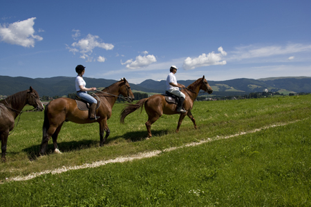
Horse trails of the Treviso and Belluno Prealps …
straddling history, taste and nature in the Alta Marca Trevigiana
This wonderful territory that connects the Prealps chain with the Venice lagoon exhibits a remarkable variety of landscapes and memories of Venetian history. Among the wonders of the Marca Trevigiana, the ‘old’ historic cities such as Treviso, Conegliano, Vittorio Veneto and Castelfranco, the stupendous Venetian Palladian and eighteenth-century villas, the suggestive walled citadels, the castles and the masterpieces of great artists such as Giorgione, Tiziano, Cima da Conegliano and Canova. And again, the hilly landscapes drawn by the ‘small’ rows of ‘great’ wines, the thick forests of Montello, the Cansiglio plain and the banks of the Piave river or along the Sile.
The Province of Treviso has dedicated an action to the enhancement of a circuit of Ippovie, with the aim of promoting a different tourism, sustainable and focused on the development of rural activities in a territory which, from a naturalistic point of view, still retains the charm of old times traits. Hence the project of the bridleways of the Treviso and Belluno Prealps: an itinerary located in a unique setting through the municipalities of Segusino, Valdobbiadene, Miane, Follina, Cison di Valmarino, Revine Lago, Vittorio Veneto, Fregona and Cappella Maggiore, along the bends of the Piave River and climbing along narrow streets that cross small inhabited hamlets that seem to have remained unchanged over time, until you reach the top of the Prealps where a panorama opens up that sweeps over the Venetian lagoon and towards the high peaks of the Dolomites.
The route winds for a length of about 266 km along a series of rings and variants that offer the rider various excursion possibilities, based on the time available and the difficulty of the journey. Along the way, the food and wine tradition of the Alta Marca Trevigiana offers tourists opportunities for a refreshment amidst the flavors, aromas and colors of the land and of the Treviso cuisine.
An unforgettable emotional journey
to discover horizons, scents, sounds and flavors
from a different point of view: riding a horse.
Immersed in nature
The bridleways have a remarkable naturalistic value. Between Valdobbiadene and Serravalle is the Prealpina ridge characterized by a rich diversified environment. Within this extensive pre-Alpine area there are sites of community interest of considerable environmental peculiarity, such as the Visentin Group with its surprising panoramas in the Vittorio Veneto area, the San Boldo Pass in the Cison di Valmarino area and Mount Cesen in the area between Segusino and Miane, crossed by numerous dirt roads, paths and sheep tracks.
When to go horseback riding
The ideal period for horseback riding along the bridleways of the Treviso and Belluno Pre-Alps starts in late spring and goes up to the beginning of autumn, when temperatures are mild and the soil is drier. The tracks in the hills or at the bottom of the valley are however passable even in winter, unless the season is particularly rainy. In any case, it is advisable to pay attention to the weather forecast in order to better plan your holiday.
The territory of the bridleways
The paths of the bridleways wind through enchanting and evocative landscapes and involve the municipalities of the Trevigiana Pedemontana starting from Segusino, Valdobbiadene, Miane, Follina, Cison di Valmarino, Revine Lago, Vittorio Veneto, Fregona up to Cappella Maggiore.
The morphological conformation of the territory is represented by a mountain range to the north (the Treviso Pre-Alps), whose ridge almost coincides with the border of the Provinces of Belluno and Treviso and which winds from the Piave valley to the Lapisina valley, which separates it from the ‘Cansiglio plateau. To the south extend the hills largely planted with vineyards, with interposed flat areas such as that of the Valsana, formerly called Sanavalle. In about two hours you can reach the ridge of the Treviso Pre-Alps, at altitudes over a thousand meters above sea level. The bridleways leading to high altitudes are traced along the country roads and paths of easy and medium difficulty. On the way up, you first cross the chestnut and acacia woods, passing through the hornbeam woods, up to the high ground pastures. The panorama includes the Val Belluna to the north, the peaks of the Dolomites in the background and the Monti del Sole in the foreground; to the south the hills and the plain with the possibility of seeing, on particularly clear days, Venice and the lagoon. Malghe, alpine refuges and farmhouses are available to tourists for a good lunch or to host them for the night, offering suitable shelters for horses as well. There are water points along the route. The tracks in the hills, more suitable for
be traveled in the late autumn period until late spring, winding through paths and roads between vineyards, woods and meadows. Along the routes you can visit the cellars where Prosecco wine is produced with the possibility of tasting. Farmhouses, old taverns and restaurants give the opportunity to taste the typical products of the area.
The bridleways also reach and cross ancient villages such as the Castrum di Serravalle with the castle, the square and the Renaissance buildings and the Parish Church of Sant’Andrea (Vittorio Veneto); Follina and its 12th century Cistercian Abbey; the Borgo di Rolle (Cison di Valmarino) nestled in the hills planted with vineyards and olive trees and defined by the poet Andrea Zanzotto as “the postcard of the gods”. Also in the municipality of Cison di Valmarino stands Castello Brandolini, an imposing medieval building set as a bulwark of the Valsana. And again the ancient rural village of Milies in the municipality of Segusino and Combai in the municipality of Miane which, in addition to being a splendid village, is the land of production of brown I.G.P.
The signs along the route
The routes of the bridleways of the Treviso and Belluno Prealps, within the Treviso area, are equipped with suitable tourist signs that are easily identifiable and bearing the numbering “TV 5” and can be traveled in both directions. The junction boxes relating to the area concerned are located at the main junctions, indicating the horse shelter or refreshment points, the water points, the naturalistic areas, the main tourist attractions and much more.
On horseback but not only …
Beyond the name and their main vocation, the bridleways of the Treviso and Belluno Prealps present the possibility of being enjoyed also by mountain bike or, why not, using comfortable trekking shoes, Nordic walking poles and a good dose of breath. .
How to get:
The routes of the bridleways are connected to each other and can be undertaken starting from each of the nine municipalities involved.
Let’s discover the various routes existing in the Province of Treviso
Segusino
Segusino is a hilly town of ancient origin whose territory extends on the left bank of the Piave river, at the foot of Monte Cesen and its extraordinary views. From a geological point of view, limestone and dolomitic rocks characterize the massif whose interest is recognized at community level. Where the Piave flows into the foothills is the so-called Garzaia di Pederobba, better known as “The City of Herons”, an important example of biodiversity that allows numerous animal and plant species to live in perfect symbiosis. This naturalistic jewel is a place of extreme beauty. In the area from Maserot to the grave of Pederobba there is a large number of water birds and thanks to its waters and the surrounding nature, entire ecosystems find their natural habitat here.
Church of Santa Lucia – in neo-Gothic style, it preserves two magnificent altars, one of which in red marble dedicated to the Madonna, and two paintings by Favotto made for the Jubilee of 2000.
Archaeological site – recently discovered, dating back to the Middle Paleolithic period. It has signs of Neanderthal man dating back to the period between 80 and 35 thousand years ago.
Fraction of Stramare – born on the threshold of the 1600s, with the Church of San Valentino flanked by a fountain made from a single piece of stone. At one time the Saint was invoked against epilepsy, called sickly transient. Today he is best known as the protector of lovers.
Fraction of Milies- with the church dedicated to Mary Help of Christians, a point of pride of the Alpini Group.
Any suggestions
The recommended routes for the municipality of Segusino are those which, starting from the center of Valdobbiadene and going up to the locality of Pianezze, staying high up to the Casere Fassina, reach the characteristic hamlet of Milies and then descend down the valley along the ancient road connecting Segusino; or always starting from Valdobbiadene, passing through the naturalistic area of Settolo Basso, continuing through the center of Segusino to go up from there to the ancient village of Stramare and then towards the woods of the hamlet of Milies.
Square of the cemetery of Valdobbiadene Pianezze – Milies Segusino km. 17.05.30 h approx.
Square of the cemetery of Valdobbiadene – Settolo Basso Bridge of Fener Segusino – Stramare – Milies km. 15.25 h approx.
Valdobbiadene
Valdobbiadene lies on the slopes of the Pre-Alps between rolling hills, groves and lush vineyards that represent the reservoir for the production of the most popular Italian wine in the world: Prosecco. In the surroundings there are numerous areas of considerable landscape interest: Pianezze, with its suggestive panoramas, is a significant example of this. Also from Valdobbiadene it is possible to reach Monte Cesen, stopping in the characteristic huts, where you can taste them
and typical mountain products. Heading south you will come across a flat naturalistic area called Settolo Basso, characterized by the presence of streams, springs, flora and fauna typical of wetlands.
The Cathedral – the current architectural line in neoclassical style, dates back to the last decade of the 1700s. Inside there are precious works of art such as the altarpiece of the High Altar dedicated to Santa Maria Assunta.
Villa dei Cedri – a former nineteenth-century factory, every year in August, it hosts the “Goblets of stars” event. It is surrounded by a large park open to the public.
Church of San Gregorio Magno in Colderove – dating back to the early thirteenth century, in 1601 a Capuchin convent was established there. The convent was suppressed in 1769 and it passed into private hands. Now only a few arches of the cloister and the ancient well remain of the convent. Today it is owned by the parish. In the 2001 restoration some details were brought to light such as the eighteenth-century crosses painted along the perimeter walls and a sundial.
The Prosecco hills – produce Prosecco and Prosecco Superiore di Cartizze, wines of excellent quality and famous throughout the world. The roads along the hills are splendid.
Pianezze – destination for walks and excursions thanks to the presence of numerous paths.
Any suggestions
From the hamlet of Guia, go up towards Pian del Brondo and then to Pian de Farnè, an area equipped for picnics with a water point for horses. Here the itinerary splits: on the left we head towards the town of Pianezze while, on the right, the route continues towards the town of Mariech. From there to the right you return towards Posa Puner; on the left you go along Val Paola, up to the Capitel di Garda. Near Capitel di Garda the route presents a crossroads: to the east you return towards Posa Puner; to the north you enter the province of Belluno; to the west, head towards the locality of Forcella, casere Fassina and the locality of Milies, in the municipality of Segusino.
Guia – Pian de Farnè – Pianezze – Mariech Busa del Pian di Vadim – Capitel di Garda km. 16.05 h approx.
Miane
The territory of Miane sees the alternation of reliefs of various sizes and valleys on which most of the housing structures have arisen which still maintain the typical rural aspect of the mountain huts and stone houses. The numerous paths cross hilly and natural areas where it is possible to admire a rich and spontaneous vegetation characterized by many chestnut groves, whose cultivation is strongly promoted for environmental improvement. A fraction of Miane, more precisely Combai, is known as the hub of the production of delicious chestnuts, with which it is possible to make numerous recipes belonging to a deep-rooted tradition.
Archpriest Church – built from 1874 to 1878. In front of it is the bell tower, formerly a lookout tower dating back to 1400 and part of a defensive and control system over the valley.
Sanctuary of the Madonna del Carmine – located in the Visnà valley at about 600 m. s.l.m. Inside there is an ancient simulacrum of the Blessed Virgin called the Madonna dei Pastori.
Borgo di Colmellere – whose name derives from Mellìus, the owner of the estate. From the Middle Ages, around the year 950, it still retains the type of structure of the time, with an open courtyard with a mixed courtyard, well and oven. Almost all the houses retain the “ritonda”, the “pioi” and other characteristic elements.
Combai – perched at the foot of the Pre-Alps and surrounded by majestic chestnut trees and centuries-old vineyards. Numerous nature trails depart from the town center. A few steps away you can admire the Cistercian Abbey of Follina (13th century), the Brandolini Castle in Cison di Valmarino, the Molinetto della Croda in Refrontolo, the ancient Pieve di San Pietro di Feletto, the Feudal Castles of Susegana and Collalto , the Sanctuary of the Madonna del Carmine in Miane.
Any suggestions
Within the municipality of Miane, the routes of greatest interest consist of a short-term loop at the Santuario del Carmine. Lovers of long journeys can start from the town center, near the Pro Loco, towards the locality of Vergoman, climbing up to reach the wonderful panorama from which you can enjoy from Posa Puner or explore the homeland of Prosecco through the hills that from Miane , passing through Guia and San Pietro di Barbozza, they reach Valdobbiadene.
Circuit Miane – near the Madonna del Carmine sanctuary km. 3,345 min approx.
Multifunctional center of Miane – Posa Puner km. 10,83.30 h approx.
Multifunctional center of Miane – Guia – Santo Stefano Saccol – San Pietro di Barbozza – Valdobbiadene km. 16.53 h approx.
orio is known for the art of wool, a tradition started by the Cistercian monks. In this regard, it is worth mentioning the Benedictine Abbey of Santa Maria (12th century), still intact today, to which the history of the town is strongly linked. A land rich in history and legends where traces of prehistoric and Roman times have been found, such as the important military communication route “Claudia Augusta Altinate”.
Abbey of Santa Maria – has the typical construction with a Latin plan. Inside there are valuable works: the large wooden altarpiece in neo-Gothic style built by Venetian workers in 1921 which houses the sandstone statue of the Madonna del Sacro Calice; the fresco “Madonna with Child and Saints” of 1527 by Francesco da Milano; a remarkable wooden crucifix from the Baroque period.
Austro-Hungarian cemetery – was born during the Austrian occupation of the Valley in November 1917. The bodies of the Austro-Hungarian soldiers exhumed from the cemeteries of Combai and Miane later converged in this cemetery.
Castelletto Brandolini – 17th century building boasts a good state of conservation. Inside there are still rooms with Sansovinian-style beams, stucco decorations, frescoes, a rich and important fireplace and other considerable works of art.
Via “Claudia Augusta Altinate” – an ancient Roman military road was completed by order of the Emperor Claudius in the century. I A.D. to connect Altino with Ausburg, the Roman Augusta, in the heart of Europe.
Any suggestions
Starting from Pian di Farrò in Follina, continue until you reach the SP 34, in front of the S.E.V factory, turn left and after traveling for about 250 meters, turn right, crossing the Soligo river. Immediately after the bridge over the river, turn right, then climb halfway up the hill heading towards the locality of Campea and from there towards the center of Miane. In Miane, passing in front of the parish church, we then head towards Località Pianezze and from there to Monte Pra Galoro.
Farrò – Premaor – Miane Loc. Costolada – Wood of Van – Pianezze – Monte Prà Galoro km. 16.05 h approx.
Cison di Valmarino
Cison di Valmarino, of ancient origins, is located in a strategic area and is the most important town in Valmareno. The charm and elegance of the past still shine through today in the city center, where there is no lack of nature and suggestive views. On the spur of the Col del Moi stands the imposing Brandolini Castle, of medieval origin, which can also be accessed via a funicular. In the valley you can go along beautiful paths of particular historical-artistic-naturalistic interest: an example is the picturesque path “Via dell’Acqua” that reaches the Bosco delle Penne Mozze, as well as the various paths that lead to the San Boldo pass, a step of particular interest with breathtaking scenery. These are routes that alternate suggestive views to wooded environments, through a natural environment still intact.
Brandolini Castle – has very ancient origins and the first nucleus should date back to the era of the barbarian invasions.
Vintage Radio Museum – the exhibition covers a period of time ranging from 1920 to the 1970s. The devices on display constitute an overview of the technical and stylistic development of the radio object, of the socio-cultural significance it has created and of the soundtrack of everyday life.
The Bosco delle Penne Mozze – an engineering masterpiece conceived and built in 1918 by the Austro-Hungarian army. It is a “scattered memorial” where the tombstones that commemorate all the Alpine troops in the province of Treviso who fell during the wars of the 1900s have been placed in the middle of the trees.
“Via dell’Acqua” – follows the course of the Rujo stream to the Penne Mozze cemetery and back.
Passo San Boldo – is a pass that connects the two sides of the central Belluno Prealps
Any suggestions
Departure from Case Teson, Gai along the route of the Via dell’Acqua, via del Molino, via Nazionale (SS635), piazza della Vittoria, via dei Santi, Pian di Zoppe, Col di Costa Magra, Pra dei Cavei, casere Monte Vecchio , Busa della Casera, Passo San Boldo and then continue along the itinerary in the province of Belluno.
Case Teson – Gai – Tovena – Passo San Boldo km. 13.54 h approx.
Revine Lake
Revine Lago is located at the foot of the southern slope of the Treviso Pre-Alps. The network of trails that winds through the area allows you to admire the areas around the lakes and the entire landscape that goes from the valley floor to the mountain. At the meeting point between the slope and the flat area there are most of the settlements where traditions, landscape and culture are still kept alive. The lake environment, in the Valmareno, is very interesting from a naturalistic point of view and consists of two separate lakes of glacial origin. The Revine lakes are part of the protected areas of recognized beauty. Cultural event now
the Revine Lago Film Fest, an international festival of short films, documentaries and screenplays, is of great importance.
The lakes – of glacial origin, was originally unique and remained so until the XIII-XIV centuries. They are now separated by a small strip of land.
Livelet Archaeological Park – an immersion in archeology and prehistoric time, the park allows you to see how our ancestors lived.
Sanctuary of San Francesco di Paola – a construction of the eighteenth century and of simple Baroque forms. For the construction of this building, local workers and artisans from all over the area were employed. Of particular interest are the frescoes by Francesco Da Re, located in one of the rooms above the sacristy, which represent the five joyful mysteries.
The “strada delle musse” and the “strada dei cavai” – two paths that go up from Revine to Pian delle Femene.
Any suggestions
The Valsana area, which stretches from Revine to Miane, is characterized by the presence of several rest stops and refreshments for horse riding. From these points the following itineraries start:
Location Cadelach – Sottocroda – La Posa km. 14.54 h approx.
Location Cadelach – Sottocroda – Soller Zuel di Là – Farrò km 16.54 h approx.
Location Cadelach – Soller – Gai – Mura – Valmareno km 14,03.30 h approx.
Vittorio Veneto
Vittorio Veneto rises on the slopes of the Treviso Pre-Alps, surrounded by gentle hills and crossed by the Meschio river. Along its banks it is possible to admire a landscape where nature and history come together in a perfect union. You can still see the remains of the mills and sawmills that worked the wood from the Cansiglio, one of the most beautiful European forests nestled in a natural basin. The still intact environment is home to many animal species and is characterized by the presence of centuries-old beech and fir trees. The historic center is basically divided into two areas: Serravalle and Ceneda. The first, with a truly enchanting square, has occupied a strategic position since ancient times: you can still see the remains of the complex Roman defensive system now close to being recognized as a World Heritage Site by UNESCO. The second, also of ancient origins, extends towards the plain and in Roman times supported the Castrum of Serravalle. From the heights of the city dominates the Sanctuary of Sant’Augusta with its particular staircase.
Cathedral – dedicated to Santa Maria Assunta and San Tiziano, in neoclassical style. Probably where the current structure stands, a place of worship existed even before the arrival in Ceneda of the body of San Tiziano di Oderzo.
Cathedral of Santa Maria Nova – in Serravalle, houses many works of art including the famous Tiziano’s altarpiece.
Castrum di Serravalle – ancient military settlement and home of the Da Camino family, represents one of the jewels of the Veneto landscape.
Castello di San Martino – very ancient, with its pentagonal tower, it is a bishopric for over a thousand years.
Museo del Cenedese – houses archaeological finds, frescoes, sculptures and paintings.
Any suggestions
Vittorio Veneto is a city of art rich in history and monuments, but it is also a city of wine and good food; its territory, by far the largest in the province of Treviso with plains, hills and mountains, connects the Valsana with the Cansiglio and the plain with the Dolomites. Its bridleways are simple because they all branch off from a single starting point in Località Sant’Andrea, located very close to the sixteenth-century center of Serravalle, then connecting to the other sections of the bridleways of the Treviso Pre-Alps.
Location Sant’Andrea – Maren – Nove – Lake Morto Caloniche – Sella del Fadalto km 15.04 h approx.
Location Sant’Andrea – Longhere – Vizza – Pian delle Femene km 18.04.30 h approx.
Sant’Andrea locality – Cadelach locality km 6.81.30 h approx.
Fregona
of the church dates back to 1462. Inside is the “Pala di San Giorgio”, one of the most beautiful panel paintings by Francesco da Milano.
Villa Trojer – from the 17th century. The stylistic elements of this villa, and in particular the two large loggias, recall the villas of the mountain areas. Although the central nucleus is baroque, the loggias are of pure Renaissance style with columns of stone and round arches. The eastern side retains original elements in the jambs of the doors open to the loggia, in the oval holes that give light to the ceiling and in the shelves that frame the roof.
Any suggestions
In the municipality of Fregona the main itinerary is the one that, starting from Vittorio Veneto, crosses Ciser, Sonego, climbing again towards Cadolten, a hamlet of Fregona, and then continues along the “del Tafarel” road until it enters a corner of unspoiled nature: the Cansiglio forest. For the excursion inside the forest, where there are protected natural areas, subject to passage restrictions, it is advisable to rely on expert guides. In this municipality, moreover, part of the route of the bridleways of the Treviso and Belluno Prealps coincides with the route of the Piave horse trail.
Sant’Andrea – Ciser – Sonego – Cadolten Forest of Cansiglio km 195.30 h approx.
Major Chapel
Cappella Maggiore, with its strategic position, is located in a characteristic and picturesque hilly area. Its urban configuration is very particular and is surrounded by housing structures that recall those of the late eighteenth century. The territory is characterized by the presence of historic villages: it is crossed by the Carron stream and is lapped by the Meschio river, of glacial origin.
Church dedicated to the Holy Trinity – the foundation of this chapel dates back to the 8th-9th century, under the dominion of the Lombards. Also known as the Mattarella church (for the name of the ancient owner of the land on which it was built).
Castelletto – of which little is known about its history. It rose around the fourth and fifth centuries. AD, following the continuous invasions of barbarians and other populations, on the hills of the area together with fortresses and other castles: Castle of King Matrucco, Castrum Theodorici and, on the hills of Cappella Maggiore, the ancient Castelletto. It gave refuge both during the barbarian invasions and during the incursions of the Hungarians and five centuries later of the Turks. Until 1970 the structure was abandoned, then bought by a painter.
Church of Santa Maria Maddalena – was originally a branch church of the parish church of Fregona until 1494, when it became an independent parish. The old church had been consecrated by the Bishop of Ceneda Pietro Leoni on 10 May 1474 and had a single nave. It was enlarged with the construction of the side naves between 1863 and 1875 and restored in 1907. The old altarpiece of the main altar entirely in carved and gilded wood is wonderful.
Any suggestions
Through the town of Cappella Maggiore, the itinerary of the bridleways of the Treviso Pre-Alps connects with the Piave horse trail, a route belonging to the Venetian Hiking Network.
Location Sant’Andrea – Cappella Maggiore km 7.21.30 h approx.
Texts and photos by the Department of Tourism of the Province of Treviso